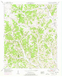
1951 Map of Campbellsville
USGS Topo · Published 1978About this map
Campbellsville stands at a rural crossroads in the mid-20th century, serving as a focal point for a landscape defined by its creek valleys and ridges. This Tennessee Valley Authority survey reveals a dense network of country churches and community schools that organized local life, from Rose Hill Sch to Owen School. The boundary between Lawrence Co and Giles Co bisects the western half of the map, where small settlements like Marcella Falls and Oak Hill are situated among a high concentration of family-named landmarks. The terrain is deeply carved by drainage systems including Weakley Creek and Factory Creek, which created the many hollows—such as Buck Hollow and Knox Hollow—that dictated the placement of homesteads and cemeteries. Genealogists will find a high density of burial grounds, including the Kimbrough Cem and Stafford Cem, illustrating the deep-rooted family ties across this agricultural region.
Find a feature on this map
83 named features on this map. Tap any name to fly to it.
Don’t see what you’re looking for? This feature index may not catch every label — zoom into the map to look around manually.
Map Details
Editions of this 1951 Campbellsville Map
4 editions found
Other maps of this area

1936 · Sandy Hook
USGS Topo · 1:24,000

1936 · Milky Way
USGS Topo · 1:24,000

1936 · Campbellsville
USGS Topo · 1:24,000

1936 · Lawrenceburg
USGS Topo · 1:24,000

1936 · Ethridge
USGS Topo · 1:24,000

1936 · Pulaski
USGS Topo · 1:24,000

1936 · Crestview
USGS Topo · 1:24,000

1936 · Bodenham
USGS Topo · 1:24,000

1936 · Lynnville
USGS Topo · 1:24,000

1948 · Bodenham
USGS Topo · 1:24,000