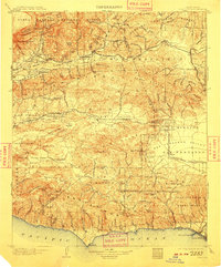
1903 Map of Camulos
USGS Topo · Published 1909About this map
Camulos stands as a focal point in this turn-of-the-century landscape, positioned along the Santa Clara River in a region transitioning from ranching heritage to modern agriculture. The map documents the early infrastructure of Ventura and Los Angeles counties, showing the reach of the Southern Pacific Railroad and its Chatsworth Park Branch. To the south, the Santa Monica Mountains meet the Pacific Ocean at Dume Point, while the rugged interior is defined by the Simi Hills and the Santa Susana Mountains. Researchers will note early settlement patterns at Newbury Park, Bardsdale, and Simi, alongside the extensive lands of the Ex Mission San Fernando. The coastal edge at Boca de Santa Monica reveals early maritime development with the presence of Port Los Angeles, contrasting with the interior's named canyons and peaks like Castro Peak and San Cayetano Mountain.
Find a feature on this map
79 named features on this map. Tap any name to fly to it.
Don’t see what you’re looking for? This feature index may not catch every label — zoom into the map to look around manually.
Map Details
Editions of this 1903 Camulos Map
5 editions found

Other maps of this area

1894 · Los Angeles
USGS Topo · 1:62,500

1896 · Redondo
USGS Topo · 1:62,500

1896 · Santa Monica
USGS Topo · 1:62,500

1898 · Santa Monica
USGS Topo · 1:62,500

1900 · Los Angeles
USGS Topo · 1:62,500

1900 · Fernando
USGS Topo · 1:62,500

1900 · Triunfo Pass
USGS Topo · 1:62,500

1900 · Piru
USGS Topo · 1:62,500

1901 · Southern California Sheet No. 1
USGS Topo · 1:250,000

1902 · Santa Monica
USGS Topo · 1:62,500