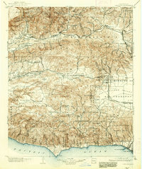
1903 Map of Camulos
USGS Topo · Published 1938About this map
The Pacific Ocean coastline at Dume Pt and the bustling railhead at Port Los Angeles anchor this turn-of-the-century perspective of the Santa Monica Mountains and the surrounding valleys. The Southern Pacific RR connects early citrus and agricultural centers like Fillmore and Bardsdale to the broader Southern California network, following the course of the Santa Clara River. Further east, the junction at Saugus and the nearby settlement of Newhall represent the vital transit corridors between the San Fernando Valley and the northern ranges.
Find a feature on this map
44 named features on this map. Tap any name to fly to it.
Don’t see what you’re looking for? This feature index may not catch every label — zoom into the map to look around manually.
Map Details
Editions of this 1903 Camulos Map
5 editions found

Other maps of this area

1894 · Los Angeles
USGS Topo · 1:62,500

1896 · Redondo
USGS Topo · 1:62,500

1896 · Santa Monica
USGS Topo · 1:62,500

1898 · Santa Monica
USGS Topo · 1:62,500

1900 · Los Angeles
USGS Topo · 1:62,500

1900 · Fernando
USGS Topo · 1:62,500

1900 · Triunfo Pass
USGS Topo · 1:62,500

1900 · Piru
USGS Topo · 1:62,500

1901 · Southern California Sheet No. 1
USGS Topo · 1:250,000

1902 · Santa Monica
USGS Topo · 1:62,500