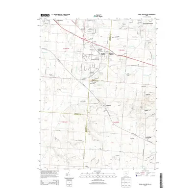
2013 Map of Canal Winchester
USGS Topo · Published 2013About this map
Canal Winchester sits at the convergence of Franklin and Fairfield counties, anchored by a rich network of early settlements and transportation corridors. This 2013 survey illustrates the developed landscape between Groveport and Pickerington, where the Us-33 corridor intersects the winding path of Walnut Creek. Significant genealogical and local history markers are found throughout the quadrangle, including the Mennonite Church Cem and the extensive Union Grove Cem. The area’s engineering history is preserved through infrastructure like the Bergstresser Covered Bridge and Loucks Covered Bridge. South of the main village, the terrain transitions toward Chestnut Ridge and smaller communities such as Lithopolis, Greencastle, and Marcy. This map provides a detailed view of the suburban and rural balance in central Ohio during the early twenty-first century, documenting every cemetery from Arlington Burial Park to the Brick Cem.
Find a feature on this map
176 named features on this map. Tap any name to fly to it.
Don’t see what you’re looking for? This feature index may not catch every label — zoom into the map to look around manually.
Map Details
Editions of this 2013 Canal Winchester Map
This is the sole edition of this map. No revisions or reprints were ever made.
Other maps of this area

1907 · Lancaster
USGS Topo · 1:62,500

1907 · Thurston
USGS Topo · 1:62,500

1909 · Lancaster
USGS Topo · 1:62,500

1909 · Thurston
USGS Topo · 1:62,500

1914 · Circleville
USGS Topo · 1:62,500

1925 · East Columbus
USGS Topo · 1:62,500

1943 · Circleville
USGS Topo · 1:62,500

1943 · East Columbus
USGS Topo · 1:62,500

1947 · Columbus
USGS Topo · 1:250,000
1955 · Lockbourne
USGS Topo · 1:24,000