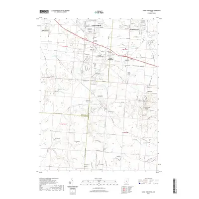
2019 Map of Canal Winchester
USGS Topo · Published 2019About this map
Canal Winchester serves as a central hub where the modern SE Expy corridor meets historical routes and watercourses. This landscape is defined by the convergence of Walnut Creek, Big Run, and the Hocking River, creating a complex drainage system that influenced early settlement patterns across the Franklin and Fairfield county lines. The area maintains several notable cultural landmarks, including the Bergstresser Covered Bridge and the Loucks Covered Bridge, which stand as physical links to nineteenth-century infrastructure.
Find a feature on this map
107 named features on this map. Tap any name to fly to it.
Don’t see what you’re looking for? This feature index may not catch every label — zoom into the map to look around manually.
Map Details
Editions of this 2019 Canal Winchester Map
This is the sole edition of this map. No revisions or reprints were ever made.
Other maps of this area

1907 · Lancaster
USGS Topo · 1:62,500

1907 · Thurston
USGS Topo · 1:62,500

1909 · Lancaster
USGS Topo · 1:62,500

1909 · Thurston
USGS Topo · 1:62,500

1914 · Circleville
USGS Topo · 1:62,500

1925 · East Columbus
USGS Topo · 1:62,500

1943 · Circleville
USGS Topo · 1:62,500

1943 · East Columbus
USGS Topo · 1:62,500

1947 · Columbus
USGS Topo · 1:250,000
1955 · Lockbourne
USGS Topo · 1:24,000