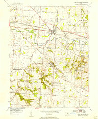
1955 Map of Canal Winchester
USGS Topo · Published 1956About this map
Canal Winchester and Lithopolis serve as the primary hubs in this mid-1950s survey of central Ohio, where the convergence of Franklin and Fairfield counties shapes the local landscape. The map reveals a transition from the industrial legacy of the Chesapeake and Ohio Canal to the active Chesapeake and Ohio railroad corridor. Notable cultural landmarks like The Wagnalls Memorial and Township Sch highlight the established civic life of these communities.
Find a feature on this map
52 named features on this map. Tap any name to fly to it.
Don’t see what you’re looking for? This feature index may not catch every label — zoom into the map to look around manually.
Map Details
Editions of this 1955 Canal Winchester Map
This is the sole edition of this map. No revisions or reprints were ever made.
Other maps of this area

1907 · Lancaster
USGS Topo · 1:62,500

1907 · Thurston
USGS Topo · 1:62,500

1909 · Lancaster
USGS Topo · 1:62,500

1909 · Thurston
USGS Topo · 1:62,500

1914 · Circleville
USGS Topo · 1:62,500

1925 · East Columbus
USGS Topo · 1:62,500

1943 · Circleville
USGS Topo · 1:62,500

1943 · East Columbus
USGS Topo · 1:62,500

1947 · Columbus
USGS Topo · 1:250,000
1955 · Lockbourne
USGS Topo · 1:24,000
Featured Places
- Columbus, OH
- Pickerington, Violet Township
- Groveport, Madison Township
- Madison Township, OH
- Slough, Bloom Township