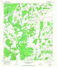
1965 Map of Canary
USGS Topo · Published 1968About this map
The Navasota River meanders through a landscape defined by complex county boundaries where Madison, Leon, Brazos, and Robertson counties converge. This mid-1960s survey documents a rural environment punctuated by small water bodies like San Antonio Lake, Duck Lake, and the Sweet Lakes. Small settlements such as Canary and Zulch anchor the local community, while scattered rural landmarks provide vital clues for genealogical research. Family names and local history are preserved in the locations of the Plainview Cem, Keefer Cem, and Nash Cem, along with Manning Ch. The presence of the Lakeside Landing Strip and Shannon Landing Strip suggests a reliance on small-scale aviation alongside traditional river crossings like Bundy Crossing. The terrain is further shaped by industrial activity, evidenced by several Gravel Pits and the natural drainage of Caney Creek and Long Hollow.
Find a feature on this map
42 named features on this map. Tap any name to fly to it.
Don’t see what you’re looking for? This feature index may not catch every label — zoom into the map to look around manually.
Map Details
Editions of this 1965 Canary Map
2 editions found
Other maps of this area

1925 · Iola No 2
USGS Topo · 1:48,000

1925 · Marquez No. 4
USGS Topo · 1:48,000

1927 · Marquez
USGS Topo · 1:62,500

1930 · Marquez
USGS Topo · 1:62,500

1931 · Iola
USGS Topo · 1:62,500

1954 · Waco
USGS Topo · 1:250,000

1954 · Austin
USGS Topo · 1:250,000

1955 · Waco
USGS Topo · 1:250,000

1959 · Clear Lake
USGS Topo · 1:24,000

1962 · Edge
USGS Topo · 1:24,000