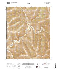
2017 Map of Candle A-2 NW
USGS Topo · Published 2017About this map
Inglutalik River carves a winding path through the Seward Peninsula in this 2017 topographic study of the Nome Census Area. The landscape is characterized by its high-latitude drainage systems, where the river and its tributary, Klusiktok Cr, are the primary geographic markers across several townships. This map provides an exact record of the terrain as it existed in the early 21st century, showing the intricate contour intervals and elevations of the surrounding highlands. Without settlements or roads recorded on the sheet, the focus remains entirely on the natural hydrography and the U.S. Geological Survey Public Land Survey System grid, which divides the territory into t3s r6w, t4s r6w, and adjacent ranges.
Find a feature on this map
8 named features on this map. Tap any name to fly to it.
Don’t see what you’re looking for? This feature index may not catch every label — zoom into the map to look around manually.
Map Details
Editions of this 2017 Candle A-2 NW Map
This is the sole edition of this map. No revisions or reprints were ever made.
Other maps of this area

1951 · Candle
USGS Topo · 1:250,000

1954 · Candle A-2
USGS Topo · 1:63,360

1954 · Candle B-2
USGS Topo · 1:63,360

1955 · Candle
USGS Topo · 1:250,000

1955 · Candle B-3
USGS Topo · 1:63,360

1955 · Candle A-2
USGS Topo · 1:63,360

1964 · Candle
USGS Topo · 1:250,000
2014 · Candle A-3 SE
USGS Topo · 1:25,000
2014 · Candle A-3 NE
USGS Topo · 1:25,000
2015 · Candle B-2 SE
USGS Topo · 1:25,000