
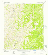
1955 Map of Candle A-2
USGS Topo · Published 1966About this map
The Inglutalik River and its network of tributaries define this mid-century landscape in the Candle area of Alaska. Mapped in 1955 by the Army Map Service using photogrammetric methods, the terrain is characterized by the winding paths of the Nigikmigoon River and the smaller Tipooktulearyk. The absence of roads or trails throughout the entire quadrangle emphasizes the remote and untouched character of the Seward Peninsula's interior during this era. High points such as Inglutalik, Kulik, and Ukit rise above the drainage basins of Garryowen Creek and Little Bear Creek. This survey represents the land lines of the Kateel River Meridian as unsurveyed and unmarked locations predetermined by the Bureau of Land Management, providing a record of the region before any modern infrastructure development reached these reaches of the Alaskan wilderness.
Find a feature on this map
9 named features on this map. Tap any name to fly to it.
Don’t see what you’re looking for? This feature index may not catch every label — zoom into the map to look around manually.
Map Details
Editions of this 1955 Candle A-2 Map
This is the sole edition of this map. No revisions or reprints were ever made.
Other maps of this area

1948 · Norton Bay
USGS Topo · 1:250,000

1950 · Norton Bay D-3
USGS Topo · 1:63,360

1951 · Candle
USGS Topo · 1:250,000

1951 · Norton Bay
USGS Topo · 1:250,000

1954 · Candle A-2
USGS Topo · 1:63,360

1954 · Candle A-1
USGS Topo · 1:63,360

1954 · Norton Bay D-2
USGS Topo · 1:63,360

1954 · Candle B-2
USGS Topo · 1:63,360

1954 · Candle B-1
USGS Topo · 1:63,360
1955 · Norton Bay D-1
USGS Topo · 1:63,360