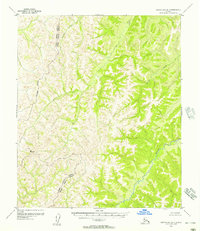
1955 Map of Norton Bay D-1
USGS Topo · Published 1957About this map
The Gisasa River flows through this interior Alaskan wilderness, following a winding course that defines the lower elevations of this high-latitude terrain. Surveyed in the mid-1950s using aerial photography, the landscape is dominated by significant elevation changes, punctuated by high points such as VABM 3245 Summit. This map captures a remote area largely defined by its natural hydrology and administrative geography, marked by the Approximate Boundary between the Second and Fourth Judicial Divisions. Small tributaries like Arvesta Creek and Caribou Creek feed into the larger river system, illustrating the drainage patterns of a region that remained without established roads or trails at the time of this publication.
Find a feature on this map
6 named features on this map. Tap any name to fly to it.
Don’t see what you’re looking for? This feature index may not catch every label — zoom into the map to look around manually.
Map Details
Editions of this 1955 Norton Bay D-1 Map
3 editions found
Other maps of this area

1945 · Nulato
USGS Topo · 1:250,000

1948 · Norton Bay
USGS Topo · 1:250,000

1951 · Candle
USGS Topo · 1:250,000

1951 · Nulato
USGS Topo · 1:250,000

1951 · Norton Bay
USGS Topo · 1:250,000

1951 · Kateel River
USGS Topo · 1:250,000

1952 · Nulato C-6
USGS Topo · 1:63,360

1952 · Nulato
USGS Topo · 1:250,000
1952 · Norton Bay C-1
USGS Topo · 1:63,360

1953 · Norton Bay C-2
USGS Topo · 1:63,360