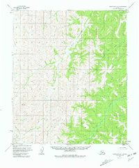
1955 Map of Norton Bay D-1
USGS Topo · Published 1981About this map
The Gisasa River and Kateel River define the interior drainage of this Alaskan wilderness within the Yukon-Koyukuk region. Compiled from aerial photographs taken during the early 1950s, the map reveals a landscape dominated by complex waterways and significant elevation markers, such as the peak at Summit. The network of tributary streams, including Arvesta Creek, Caribou Creek, and Egusik Creek, illustrates a natural hydraulic system prior to significant modern development. This survey serves as a fundamental record of land lines and unmarked locations predetermined by the Bureau of Land Management, providing an essential view of the region's geography during a period of extensive federal topographic mapping in the Alaska territory.
Find a feature on this map
6 named features on this map. Tap any name to fly to it.
Don’t see what you’re looking for? This feature index may not catch every label — zoom into the map to look around manually.
Map Details
Editions of this 1955 Norton Bay D-1 Map
3 editions found
Other maps of this area

1945 · Nulato
USGS Topo · 1:250,000

1948 · Norton Bay
USGS Topo · 1:250,000

1951 · Candle
USGS Topo · 1:250,000

1951 · Nulato
USGS Topo · 1:250,000

1951 · Norton Bay
USGS Topo · 1:250,000

1951 · Kateel River
USGS Topo · 1:250,000

1952 · Nulato C-6
USGS Topo · 1:63,360

1952 · Nulato
USGS Topo · 1:250,000
1952 · Norton Bay C-1
USGS Topo · 1:63,360

1953 · Norton Bay C-2
USGS Topo · 1:63,360