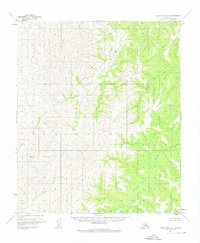
1955 Map of Norton Bay D-1
USGS Topo · Published 1975About this map
The Gisasa River and Kateel River systems define this remote interior landscape within the Yukon-Koyukuk region. Mapped via photogrammetric methods from 1950s aerial photography, the terrain is characterized by a dense network of watercourses, including Arvesta Creek and Caribou Creek, which drain the surrounding highlands toward the river valleys. The lack of roads, trails, or settlements in this mid-century survey reflects the wilderness character of the area, where land use was primarily governed by the Bureau of Land Management. A solitary Summit stands as a primary topographical reference point amidst the intricate contour work that traces the elevation changes between the Egusik Creek drainage and the larger river basins. This map provides a precise record of the natural hydrology and undeveloped state of the Alaskan interior before modern infrastructure reached these corridors.
Find a feature on this map
6 named features on this map. Tap any name to fly to it.
Don’t see what you’re looking for? This feature index may not catch every label — zoom into the map to look around manually.
Map Details
Editions of this 1955 Norton Bay D-1 Map
3 editions found
Other maps of this area

1945 · Nulato
USGS Topo · 1:250,000

1948 · Norton Bay
USGS Topo · 1:250,000

1951 · Candle
USGS Topo · 1:250,000

1951 · Nulato
USGS Topo · 1:250,000

1951 · Norton Bay
USGS Topo · 1:250,000

1951 · Kateel River
USGS Topo · 1:250,000

1952 · Nulato C-6
USGS Topo · 1:63,360

1952 · Nulato
USGS Topo · 1:250,000
1952 · Norton Bay C-1
USGS Topo · 1:63,360

1953 · Norton Bay C-2
USGS Topo · 1:63,360