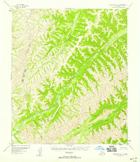
1952 Map of Norton Bay C-1
USGS Topo · Published 1959About this map
The Nulato River carves a deep path through this interior Alaskan wilderness, as documented by aerial photography from the early 1950s. This survey focuses on the intricate topography of the northern territory, where the Second Judicial Division and Fourth Judicial Division meet along an Approximate Boundary. The landscape is defined by its dramatic relief and lack of human infrastructure, represented primarily by geographic markers such as VABM Baker 3114. This record from the Geological Survey provides an essential baseline of the region's hydrography and terrain before later development, showing the complex tributary systems feeding the main river valley.
Find a feature on this map
4 named features on this map. Tap any name to fly to it.
Don’t see what you’re looking for? This feature index may not catch every label — zoom into the map to look around manually.
Map Details
Editions of this 1952 Norton Bay C-1 Map
2 editions found
Other maps of this area

1945 · Nulato
USGS Topo · 1:250,000

1948 · Norton Bay
USGS Topo · 1:250,000

1951 · Nulato
USGS Topo · 1:250,000

1951 · Norton Bay
USGS Topo · 1:250,000

1952 · Nulato B-6
USGS Topo · 1:63,360

1952 · Norton Bay B-1
USGS Topo · 1:63,360

1952 · Nulato C-6
USGS Topo · 1:63,360

1952 · Nulato
USGS Topo · 1:250,000
1953 · Norton Bay B-2
USGS Topo · 1:63,360

1953 · Norton Bay C-2
USGS Topo · 1:63,360