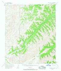
1952 Map of Norton Bay C-1
USGS Topo · Published 1967About this map
Gisasa River winds through the northern interior of the Seward Peninsula region, eventually meeting the Nulato River as it cuts westward toward Norton Bay. This map, based on 1952 aerial photography, documents a wilderness landscape defined almost entirely by its hydrography and topography. The lack of roads, trails, or permanent settlements in this sector reflects the extreme isolation of the territory during the mid-twentieth century. Researchers focusing on the historical drainage patterns of the western Yukon-Koyukuk region will find the precise elevations and the convergence of these two major river systems particularly useful, as the map illustrates the natural corridors that have historically dictated movement through the Alaskan interior.
Find a feature on this map
2 named features on this map. Tap any name to fly to it.
Don’t see what you’re looking for? This feature index may not catch every label — zoom into the map to look around manually.
Map Details
Editions of this 1952 Norton Bay C-1 Map
2 editions found
Other maps of this area

1945 · Nulato
USGS Topo · 1:250,000

1948 · Norton Bay
USGS Topo · 1:250,000

1951 · Nulato
USGS Topo · 1:250,000

1951 · Norton Bay
USGS Topo · 1:250,000

1952 · Nulato B-6
USGS Topo · 1:63,360

1952 · Norton Bay B-1
USGS Topo · 1:63,360

1952 · Nulato C-6
USGS Topo · 1:63,360

1952 · Nulato
USGS Topo · 1:250,000
1952 · Norton Bay C-1
USGS Topo · 1:63,360
1953 · Norton Bay B-2
USGS Topo · 1:63,360