
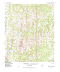
1950 Map of Norton Bay D-3
USGS Topo · Published 1958About this map
Ungalik River provides the primary orientation for this 1950 topographical study of the Alaskan interior near Norton Bay. The terrain is characterized by an intricate drainage network where countless unnamed streams and tributaries carve through the upland landscape. While no settlements, roads, or trails are marked on this sheet, the map serves as a highly detailed record of the natural topography as it existed in the mid-20th century. Mapped by the Army Map Service using aerial photography, the contours illustrate the significant elevation changes and hydrological patterns that defined this wilderness area during the early Cold War era, providing a precise baseline for geological or environmental research in the Second Judicial Division.
Find a feature on this map
1 named feature on this map. Tap any name to fly to it.
Don’t see what you’re looking for? This feature index may not catch every label — zoom into the map to look around manually.
Map Details
Editions of this 1950 Norton Bay D-3 Map
2 editions found
Other maps of this area

1948 · Norton Bay
USGS Topo · 1:250,000

1950 · Norton Bay D-4
USGS Topo · 1:63,360

1950 · Norton Bay C-3
USGS Topo · 1:63,360

1950 · Norton Bay C-4
USGS Topo · 1:63,360

1951 · Candle
USGS Topo · 1:250,000

1951 · Norton Bay
USGS Topo · 1:250,000

1953 · Norton Bay C-2
USGS Topo · 1:63,360

1954 · Candle A-2
USGS Topo · 1:63,360

1954 · Norton Bay D-2
USGS Topo · 1:63,360

1955 · Candle
USGS Topo · 1:250,000