
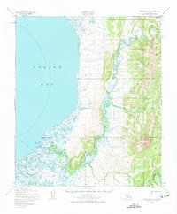
1950 Map of Norton Bay C-4
USGS Topo · Published 1958About this map
Norton Bay defines the western edge of this 1950 coastal study, where the tidal flats meet a network of waterways and high terrain. The Ungalik River meanders through the central landscape, fed by tributaries like Christmas Creek as it flows toward the coast. While the interior is largely dominated by topographic relief, signs of seasonal or remote habitation are marked by several isolated Cabin sites along the riverbanks and coastal transition zones. This map, based on aerial photography from the mid-century, records the drainage patterns and shoreline before significant modern changes, providing a clear view of the natural corridors used by travelers in the Second Judicial Division of Alaska.
Find a feature on this map
4 named features on this map. Tap any name to fly to it.
Don’t see what you’re looking for? This feature index may not catch every label — zoom into the map to look around manually.
Map Details
Editions of this 1950 Norton Bay C-4 Map
2 editions found
Other maps of this area

1948 · Norton Bay
USGS Topo · 1:250,000

1950 · Norton Bay B-5
USGS Topo · 1:63,360

1950 · Norton Bay D-5
USGS Topo · 1:63,360

1950 · Norton Bay B-4
USGS Topo · 1:63,360

1950 · Norton Bay D-4
USGS Topo · 1:63,360

1950 · Norton Bay C-5
USGS Topo · 1:63,360

1950 · Norton Bay B-3
USGS Topo · 1:63,360

1950 · Norton Bay C-3
USGS Topo · 1:63,360

1950 · Norton Bay D-3
USGS Topo · 1:63,360

1951 · Norton Bay
USGS Topo · 1:250,000