
1950 Map of Norton Bay C-5
USGS Topo · Published 1958About this map
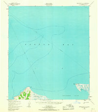
Reindeer Reservation land and the waters of Norton Bay dominate this mid-century coastal survey. The map depicts a landscape defined by seasonal movement and the heritage of reindeer herding, with a prominent Winter Trail (Approximate) cutting across the ice and shoreline. The terrain is marked by coastal features like Pt Dexter and the elevated Reindeer Hills, providing a clear look at the topography before modern developments. Along the southeastern shoreline, Reindeer Cove opens up near a small Cabin and the triangulation point at Pussy VABM. These details reflect a period when traditional routes and subsistence land use were primary, as seen in the extensive Tidal Flat areas near Little Mountain and Island Pt.
Find a feature on this map
11 named features on this map. Tap any name to fly to it.
Don’t see what you’re looking for? This feature index may not catch every label — zoom into the map to look around manually.
Map Details
Editions of this 1950 Norton Bay C-5 Map
2 editions found
Other maps of this area

1948 · Norton Bay
USGS Topo · 1:250,000

1950 · Norton Bay D-6
USGS Topo · 1:63,360

1950 · Norton Bay B-5
USGS Topo · 1:63,360

1950 · Norton Bay D-5
USGS Topo · 1:63,360

1950 · Norton Bay B-4
USGS Topo · 1:63,360

1950 · Norton Bay C-6
USGS Topo · 1:63,360

1950 · Norton Bay D-4
USGS Topo · 1:63,360

1950 · Norton Bay C-4
USGS Topo · 1:63,360

1951 · Norton Bay
USGS Topo · 1:250,000

1955 · Norton Bay
USGS Topo · 1:250,000