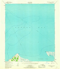
1950 Map of Norton Bay C-5
USGS Topo · Published 1968About this map
Reindeer Reservation land borders the southern shoreline of Norton Bay, reflecting the unique pastoral history of the Seward Peninsula in the mid-twentieth century. The map depicts a predominantly maritime and coastal landscape, where the frozen expanse of the bay was navigated via a Winter Trail (Approximate) that cut across the ice. This path provided a seasonal connection across the water, a common transit method in this region before permanent road infrastructure was established. On the eastern shore, distinctive landmarks like Little Mountain and the survey point Pussy VABM 119 stand above the marshy coastal lowlands. This survey, compiled from 1950 aerial photography and early 1900s hydrographic data, captures the intersection of traditional seasonal travel routes and early federal land management in western Alaska.
Find a feature on this map
5 named features on this map. Tap any name to fly to it.
Don’t see what you’re looking for? This feature index may not catch every label — zoom into the map to look around manually.
Map Details
Editions of this 1950 Norton Bay C-5 Map
2 editions found
Other maps of this area

1948 · Norton Bay
USGS Topo · 1:250,000

1950 · Norton Bay D-6
USGS Topo · 1:63,360

1950 · Norton Bay B-5
USGS Topo · 1:63,360

1950 · Norton Bay D-5
USGS Topo · 1:63,360

1950 · Norton Bay B-4
USGS Topo · 1:63,360

1950 · Norton Bay C-6
USGS Topo · 1:63,360

1950 · Norton Bay D-4
USGS Topo · 1:63,360

1950 · Norton Bay C-5
USGS Topo · 1:63,360

1950 · Norton Bay C-4
USGS Topo · 1:63,360

1951 · Norton Bay
USGS Topo · 1:250,000