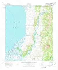
1950 Map of Norton Bay C-4
USGS Topo · Published 1974About this map
Norton Bay meets a labyrinthine coastal landscape of tidal flats and meandering river systems in this 1950s-era study. The Ungalik River and Shaktoolik River dominate the low-lying terrain, creating a complex network of waterways including First Creek and Willow Creek. Inland, the elevation rises toward Christmas Mountain, providing a stark contrast to the saturated coastal marshes. Human presence is sparse but clearly defined by a Winter Trail cutting across the southwestern quadrant and a lone Cabin situated near the riverbanks. This map, based on 1950 aerial photography with hydrographic data roots reaching back to 1900, captures the remote character of the region before significant modern development, showing the vital connection between the shoreline and the interior highlands via Christmas Creek.
Find a feature on this map
10 named features on this map. Tap any name to fly to it.
Don’t see what you’re looking for? This feature index may not catch every label — zoom into the map to look around manually.
Map Details
Editions of this 1950 Norton Bay C-4 Map
2 editions found
Other maps of this area

1948 · Norton Bay
USGS Topo · 1:250,000

1950 · Norton Bay B-5
USGS Topo · 1:63,360

1950 · Norton Bay D-5
USGS Topo · 1:63,360

1950 · Norton Bay B-4
USGS Topo · 1:63,360

1950 · Norton Bay D-4
USGS Topo · 1:63,360

1950 · Norton Bay C-5
USGS Topo · 1:63,360

1950 · Norton Bay B-3
USGS Topo · 1:63,360

1950 · Norton Bay C-3
USGS Topo · 1:63,360

1950 · Norton Bay D-3
USGS Topo · 1:63,360

1950 · Norton Bay C-4
USGS Topo · 1:63,360