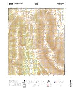
2017 Map of Candle A-6 SW
USGS Topo · Published 2017About this map
The upper reaches of the Kwik River basin dominate this landscape in the Nome Census Area of Alaska. This survey details the high-latitude drainage systems that define the Seward Peninsula's interior, where Salmon Cr and Flat Cr flow through distinct township sections such as t4s r16w and t5s r16w. The terrain is characterized by a dense network of seasonal and perennial watercourses, including the headwaters of Kwik Cr. Without permanent settlements or roads, the map serves as a primary record of the topographic contours and hydrological patterns essential for understanding the natural geography and potential mineral exploration routes in this remote region. The precise delineation of township and range lines provides a structural framework for land identification in a wilderness area devoid of modern infrastructure.
Find a feature on this map
10 named features on this map. Tap any name to fly to it.
Don’t see what you’re looking for? This feature index may not catch every label — zoom into the map to look around manually.
Map Details
Editions of this 2017 Candle A-6 SW Map
This is the sole edition of this map. No revisions or reprints were ever made.
Other maps of this area

1948 · Norton Bay
USGS Topo · 1:250,000

1950 · Bendeleben A-1
USGS Topo · 1:63,360

1950 · Norton Bay D-6
USGS Topo · 1:63,360

1950 · Bendeleben
USGS Topo · 1:250,000

1950 · Solomon D-1
USGS Topo · 1:63,360

1950 · Solomon
USGS Topo · 1:250,000

1950 · Candle A-6
USGS Topo · 1:63,360

1951 · Candle
USGS Topo · 1:250,000

1951 · Bendeleben
USGS Topo · 1:250,000

1951 · Solomon
USGS Topo · 1:250,000