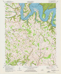
1970 Map of Cane Valley
USGS Topo · Published 1975About this map
The waters of Green River Lake dominate the northern terrain of this map, winding past prominent topographical features like Pike Ridge and Buffalo Cliff. This 1970 revision captures a landscape defined by the transition from river bottomlands to the uplands of the Taylor and Adair county line. The map is particularly valuable for genealogical research, documenting numerous family-named landmarks and historical sites such as the Green River Hill Confederate Cem near Romine, and the Faulkner Sulphur Spring further south. The settlement of Cane Valley sits at a central crossroads, surrounded by a network of rural institutions including Cane Valley Ch and several small family burial grounds. To the south, the landscape is drained by Russell Creek, with the map detailing various rural industrial and natural features like local quarries and Saltpeter Cave.
Find a feature on this map
55 named features on this map. Tap any name to fly to it.
Don’t see what you’re looking for? This feature index may not catch every label — zoom into the map to look around manually.
Map Details
Editions of this 1970 Cane Valley Map
4 editions found
Other maps of this area

1952 · Mannsville
USGS Topo · 1:24,000

1953 · Gradyville
USGS Topo · 1:24,000

1953 · Campbellsville
USGS Topo · 1:24,000

1953 · Montpelier
USGS Topo · 1:24,000

1953 · Gresham
USGS Topo · 1:24,000

1953 · Cane Valley
USGS Topo · 1:24,000

1954 · Knifley
USGS Topo · 1:24,000

1954 · Columbia
USGS Topo · 1:24,000

1954 · Greensburg
USGS Topo · 1:24,000

1957 · Winchester
USGS Topo · 1:250,000