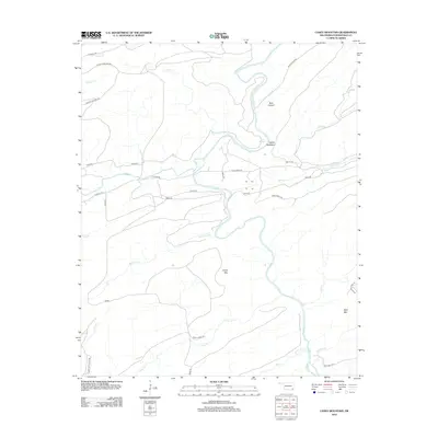
2012 Map of Caney Mountain
USGS Topo · Published 2012About this map
The Little River meanders through this portion of Pushmataha County, carving a deep path through a landscape defined by significant ridges and narrow drainages. The waterway passes beneath the prominent Devils Backbone and flows near Iron Springs, serving as the primary drainage for numerous tributaries like Cloudy Cr, Holly Cr, and Rock Pen Cr. The terrain is marked by distinctive heights including Caney Mtn and Wolf Mtn, which overlook a network of backcountry routes. These paths, such as the Harry Rowe Trl and Caney Creek Trl, follow the natural contours of the ridges and valleys. The distribution of these trails and roads suggests a region utilized for timber management or remote recreation, with named features like Bear Canyon highlighting the isolated and localized nomenclature of this Oklahoma wilderness.
Find a feature on this map
35 named features on this map. Tap any name to fly to it.
Don’t see what you’re looking for? This feature index may not catch every label — zoom into the map to look around manually.
Map Details
Editions of this 2012 Caney Mountain Map
This is the sole edition of this map. No revisions or reprints were ever made.
Other maps of this area

1901 · Alikchi
USGS Topo · 1:125,000

1950 · Mcalester
USGS Topo · 1:250,000

1962 · McAlester
USGS Topo · 1:250,000

1962 · Sobol
USGS Topo · 1:24,000

1962 · Caney Mountain
USGS Topo · 1:24,000

1962 · Alikchi
USGS Topo · 1:24,000

1962 · Signal Mountain
USGS Topo · 1:24,000

1965 · McAlester
USGS Topo · 1:250,000

1971 · Spencerville
USGS Topo · 1:24,000
1972 · Clebit
USGS Topo · 1:24,000