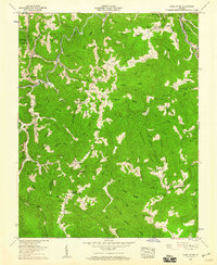
1958 Map of Caney Ridge
USGS Topo · Published 1960About this map
Caney Ridge and the Wise Co Dickenson Co line define this segment of the Appalachian Plateau during a period of active resource extraction and decentralized mountain settlement. The landscape is characterized by narrow ridges like Porter Ridge and Rockhouse Ridge, where communities were organized around small family-named churches and schools. Local life is anchored at Darwin and Omaha, with post offices at Millard and Lock serving the surrounding hollows. Evidence of the region's industrial transitions is visible in several strip mines and infrastructure such as the Bearpen Gap Tunnel and Caney Tunnel. Genealogists will find a high density of burial sites, including the Stanley, Hibbitts, and McCoy cemeteries, many situated near long-standing congregations like Lebanon Ch and Rachel Chapel.
Find a feature on this map
110 named features on this map. Tap any name to fly to it.
Don’t see what you’re looking for? This feature index may not catch every label — zoom into the map to look around manually.
Map Details
Editions of this 1958 Caney Ridge Map
2 editions found
Other maps of this area

1886 · Grundy
USGS Topo · 1:125,000

1890 · Whitesburg
USGS Topo · 1:125,000

1890 · Grundy
USGS Topo · 1:125,000

1892 · Grundy
USGS Topo · 1:125,000

1892 · Whitesburg
USGS Topo · 1:125,000

1894 · Estillville
USGS Topo · 1:125,000

1897 · Bristol
USGS Topo · 1:125,000

1902 · Bristol
USGS Topo · 1:125,000

1912 · Pound
USGS Topo · 1:48,000

1913 · Clintwood
USGS Topo · 1:62,500