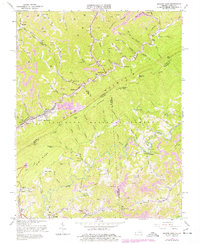
1963 Map of Jenkins East
USGS Topo · Published 1978About this map
Pine Mountain dominates this landscape along the border of Virginia and Kentucky, where the Jefferson National Forest meets a region defined by extensive resource extraction. The industrial character of the mid-20th century is evident through the dense concentration of Strip Mines, Gas Wells, and Oil Wells that populate the hollows and ridges. This coal and gas economy is physically linked by the Chesapeake and Ohio railroad, which follows the winding course of Elkhorn Creek through the towns of Jenkins and Burdine.
Find a feature on this map
110 named features on this map. Tap any name to fly to it.
Don’t see what you’re looking for? This feature index may not catch every label — zoom into the map to look around manually.
Map Details
Editions of this 1963 Jenkins East Map
3 editions found
Other maps of this area

1886 · Grundy
USGS Topo · 1:125,000

1890 · Whitesburg
USGS Topo · 1:125,000

1890 · Grundy
USGS Topo · 1:125,000

1892 · Grundy
USGS Topo · 1:125,000

1892 · Whitesburg
USGS Topo · 1:125,000

1912 · Pound
USGS Topo · 1:48,000

1913 · Clintwood
USGS Topo · 1:62,500

1914 · Pound
USGS Topo · 1:62,500

1914 · Vergie
USGS Topo · 1:48,000

1915 · Clintwood
USGS Topo · 1:62,500