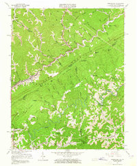
1963 Map of Jenkins East
USGS Topo · Published 1965About this map
Pine Mountain dominates this 1963 survey, serving as a formidable natural barrier between the coal-rich valleys of Kentucky and the highlands of Virginia. This topographical study captures the industrial landscape of the Central Appalachians at a time of heavy resource extraction, evidenced by numerous strip mines, a Quarry, and the Chesapeake and Ohio railroad corridor. The settlement patterns follow the narrow hollows, where small communities like Shelby Gap and Beefhide are established alongside numerous country institutions. Genealogy researchers will find several local landmarks including Bethel Ch, Francis Pine Chapel, and the Austin Cem. The southern portion of the map transitions into the protected timberlands of the Jefferson National Forest, where the terrain drops toward the Pound River valley, revealing a landscape defined by sharp ridges and deep gap crossings like Osborn Gap and Georges Fork Gap.
Find a feature on this map
109 named features on this map. Tap any name to fly to it.
Don’t see what you’re looking for? This feature index may not catch every label — zoom into the map to look around manually.
Map Details
Editions of this 1963 Jenkins East Map
3 editions found
Other maps of this area

1886 · Grundy
USGS Topo · 1:125,000

1890 · Whitesburg
USGS Topo · 1:125,000

1890 · Grundy
USGS Topo · 1:125,000

1892 · Grundy
USGS Topo · 1:125,000

1892 · Whitesburg
USGS Topo · 1:125,000

1912 · Pound
USGS Topo · 1:48,000

1913 · Clintwood
USGS Topo · 1:62,500

1914 · Pound
USGS Topo · 1:62,500

1914 · Vergie
USGS Topo · 1:48,000

1915 · Clintwood
USGS Topo · 1:62,500