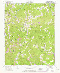
1958 Map of Caney Ridge
USGS Topo · Published 1976About this map
Cranes Nest River and the McClure River define the intricate drainage patterns of this Southwest Virginia landscape, which is marked by a high density of family cemeteries and local institutions. Small communities like Darwin, Omaha, and Frogpond are connected by winding mountain roads that pass numerous country churches such as Lebanon Ch, Sweet Home Ch, and Pippin Chapel. The presence of several strip mines indicates the area's industrial ties to coal during the mid-20th century, while landmarks like the Bearpen Gap Tunnel and Caney Tunnel show the engineering required to navigate this topography. Local history is deeply embedded in the land, with dozens of named burial grounds including Mullins Cem, Stanley Cem, and Buchanan Cem situated near rural schools like Millard Sch and Kenady Sch.
Find a feature on this map
130 named features on this map. Tap any name to fly to it.
Don’t see what you’re looking for? This feature index may not catch every label — zoom into the map to look around manually.
Map Details
Editions of this 1958 Caney Ridge Map
2 editions found
Other maps of this area

1886 · Grundy
USGS Topo · 1:125,000

1890 · Whitesburg
USGS Topo · 1:125,000

1890 · Grundy
USGS Topo · 1:125,000

1892 · Grundy
USGS Topo · 1:125,000

1892 · Whitesburg
USGS Topo · 1:125,000

1894 · Estillville
USGS Topo · 1:125,000

1897 · Bristol
USGS Topo · 1:125,000

1902 · Bristol
USGS Topo · 1:125,000

1912 · Pound
USGS Topo · 1:48,000

1913 · Clintwood
USGS Topo · 1:62,500