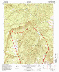
1995 Map of Canjilon SE
USGS Topo · Published 1997About this map
The land grants of northern New Mexico define this high-elevation landscape, where the Juan Jose Lobato Grant and Plaza Colorada Grant meet within the boundaries of the Carson National Forest. The map documents a rugged terrain carved by numerous arroyos and canyons, including the significant Cañon de la Madera and Cañon del Cobre. These drainages lead toward lower elevations, while peaks like Sierra Negra rise above the surrounding mesas and flats like Llano Blanco. Evidence of historical land use and resource extraction is visible through labels for the Stock Tanks Mine and Las Minas de Pedro (Inactive). Water, a critical resource in this arid environment, is meticulously recorded through a series of springs and ojitos, such as Ojito de las Cienaguitas and Ojito Carrizo, which served as vital points for livestock and early settlers.
Find a feature on this map
30 named features on this map. Tap any name to fly to it.
Don’t see what you’re looking for? This feature index may not catch every label — zoom into the map to look around manually.
Map Details
Editions of this 1995 Canjilon SE Map
This is the sole edition of this map. No revisions or reprints were ever made.
Other maps of this area

1918 · Abiquiu
USGS Topo · 1:125,000

1953 · Canones
USGS Topo · 1:24,000

1953 · Abiquiu
USGS Topo · 1:24,000

1953 · Medanales
USGS Topo · 1:24,000

1953 · Valle Grande Peak
USGS Topo · 1:24,000

1953 · Magote Peak
USGS Topo · 1:24,000

1953 · Canjilon
USGS Topo · 1:24,000

1953 · El Rito
USGS Topo · 1:24,000

1953 · Canjilon SE
USGS Topo · 1:24,000

1953 · Ghost Ranch
USGS Topo · 1:24,000