
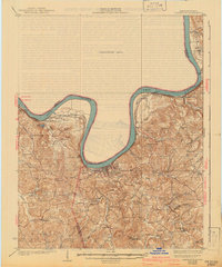
1934 Map of Cannelton
USGS Topo · Published 1934About this map
The Ohio River dictates the landscape of this 1934 survey, carving a deep serpentine path between Indiana and Kentucky. The riverfront towns of Hawesville and Cannelton anchor the western edge, while Cloverport sits at a sharp southern bend where Clover Creek meets the main channel. The interior terrain is exceptionally dissected, characterized by numerous ridges and hollows that necessitated a dense network of local schools like Happy Hollow School and Duncan School to serve the rural population.
Find a feature on this map
57 named features on this map. Tap any name to fly to it.
Don’t see what you’re looking for? This feature index may not catch every label — zoom into the map to look around manually.
Map Details
Editions of this 1934 Cannelton Map
2 editions found
Other maps of this area

1900 · St Meinrad
USGS Topo · 1:62,500

1903 · St. Meinrad
USGS Topo · 1:62,500

1903 · Tell City
USGS Topo · 1:62,500

1907 · Whitesville
USGS Topo · 1:62,500

1909 · Whitesville
USGS Topo · 1:62,500

1928 · Hardinsburg
USGS Topo · 1:48,000

1931 · Hardinsburg
USGS Topo · 1:62,500

1932 · Fordsville
USGS Topo · 1:62,500

1947 · Lodiburg
USGS Topo · 1:24,000

1947 · Hardinsburg
USGS Topo · 1:24,000