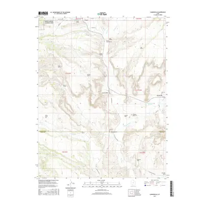
2017 Map of Cannonville
USGS Topo · Published 2017About this map
Tropic, Cannonville, and Henrieville anchor this southern Utah landscape, where small-scale settlement meets the stark geography of the Paria River basin. The area is defined by its dramatic relief, from the edge of Bryce Canyon National Park in the northwest to the expansive Tropic Valley. Local heritage is preserved in sites like the Cannonville Cem and Henrieville Cem, while the defunct settlement of Georgetown near the Garfield and Kane County line reflects the shifting patterns of rural life. The mapping of named water sources such as Henrieville Creek and Yellow Creek, alongside engineering features like Johnson Storage Reservoir, underscores the critical role of water management in this arid environment. Landmark features such as Promise Rock Arch and Shepherd Point highlight the unique erosional geology that characterizes the Paria Amphitheater and its surrounding benches.
Find a feature on this map
55 named features on this map. Tap any name to fly to it.
Don’t see what you’re looking for? This feature index may not catch every label — zoom into the map to look around manually.
Map Details
Editions of this 2017 Cannonville Map
This is the sole edition of this map. No revisions or reprints were ever made.
Other maps of this area

1886 · Kanab
USGS Topo · 1:250,000

1886 · Escalante
USGS Topo · 1:250,000

1953 · Cedar City
USGS Topo · 1:250,000

1956 · Escalante
USGS Topo · 1:250,000

1958 · Cedar City
USGS Topo · 1:250,000

1960 · Escalante
USGS Topo · 1:250,000

1962 · Cedar City
USGS Topo · 1:250,000

1964 · Henrieville
USGS Topo · 1:24,000
1964 · Pine Lake
USGS Topo · 1:24,000
1964 · Slickrock Bench
USGS Topo · 1:24,000