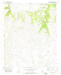
1971 Map of Canon Pedroso
USGS Topo · Published 1975About this map
Pedroso Creek defines the primary drainage of this arid terrain in northeastern New Mexico, winding through the Cañon Pedroso as it descends through the mesa country. This 1971 survey, based on aerial photography from the previous year, captures a transition in the high plains landscape between the Mora and Las Vegas land grants. The map is primarily a study of topography and relief, showing the stark contrast between the flat upland plains and the deeply incised canyon systems that characterize the San Miguel County region. Sparse development and minimal infrastructure suggest a landscape dedicated to large-scale ranching and grazing, where water sources like the creek were the essential focal points for land use and movement.
Find a feature on this map
3 named features on this map. Tap any name to fly to it.
Don’t see what you’re looking for? This feature index may not catch every label — zoom into the map to look around manually.
Map Details
Editions of this 1971 Canon Pedroso Map
This is the sole edition of this map. No revisions or reprints were ever made.
Other maps of this area

1892 · Watrous
USGS Topo · 1:125,000

1894 · Watrous
USGS Topo · 1:125,000

1954 · Santa Fe
USGS Topo · 1:250,000

1958 · Santa Fe
USGS Topo · 1:250,000

1964 · Frutosa Lake
USGS Topo · 1:24,000
1966 · Watrous
USGS Topo · 1:24,000
1966 · Cherry Valley Lake
USGS Topo · 1:24,000
1971 · Goetsch Lake
USGS Topo · 1:24,000

1971 · Laguna Huerfana
USGS Topo · 1:24,000

1971 · Trujillo
USGS Topo · 1:24,000