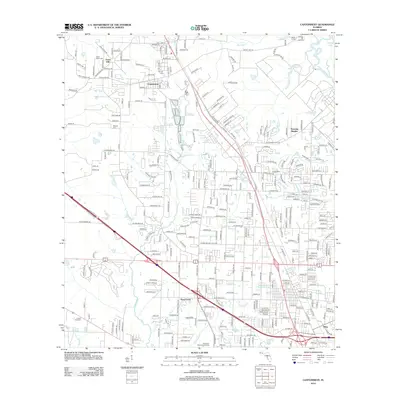
2012 Map of Cantonment
USGS Topo · Published 2012About this map
The Escambia River defines the eastern boundary of this region, which transitioned into a significant residential and industrial hub north of Pensacola by the early 21st century. Cantonment serves as the central settlement, surrounded by several smaller communities like Farm Hill, Pine Forest, and Satsuma Heights. The landscape is intricately marked by a network of waterways, including the winding paths of Elevenmile Creek and Eightmile Creek, which are interspersed with long-standing local landmarks. Genealogists will find notable value in the numerous burial sites documented here, such as Spreull Cemetery, Mission Cemetery, and Jordan Cemetery. To the southwest, the Philpot Fire Tower stands as a point of interest, while the Pensacola Memorial Gardens occupies a large tract near the highway junction. This 2012 survey illustrates the dense residential growth and road development that characterized the area during this era.
Find a feature on this map
153 named features on this map. Tap any name to fly to it.
Don’t see what you’re looking for? This feature index may not catch every label — zoom into the map to look around manually.
Map Details
Editions of this 2012 Cantonment Map
This is the sole edition of this map. No revisions or reprints were ever made.
Other maps of this area

1920 · Milton
USGS Topo · 1:62,500

1921 · Pensacola
USGS Topo · 1:62,500

1921 · Fort Barrancas
USGS Topo · 1:62,500

1921 · Muscogee
USGS Topo · 1:62,500

1941 · Fort Barrancas
USGS Topo · 1:62,500

1941 · Muscogee
USGS Topo · 1:62,500

1941 · Pensacola
USGS Topo · 1:62,500

1941 · Milton
USGS Topo · 1:62,500

1942 · Pensacola
USGS Topo · 1:62,500

1943 · Muscogee
USGS Topo · 1:62,500