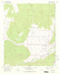
1978 Map of Canyon Day
USGS Topo · Published 1978About this map
Kinishba Ruins stands as a central archaeological landmark in this portion of the Fort Apache Indian Reservation, located just north of the White River. The landscape is defined by its water management and early transportation routes, featuring numerous stock tanks like Sawtooth Tank and Amos Tank that supported cattle ranching operations. The Old Military Road cuts across the eastern sector, passing near the settlement of Canyon Day and the nearby Stockman Station. This mid-1970s record illustrates a transition in land use, where ancient ruins and historical military trails intersect with modern tribal infrastructure. Notable topographic features such as Sawtooth Mtn and Tsay-se-zhin Butte dominate the horizon, while Bear Canyon and the Sevenmile Rim delineate the drainage patterns leading toward the river valley.
Find a feature on this map
36 named features on this map. Tap any name to fly to it.
Don’t see what you’re looking for? This feature index may not catch every label — zoom into the map to look around manually.
Map Details
Editions of this 1978 Canyon Day Map
This is the sole edition of this map. No revisions or reprints were ever made.
Other maps of this area

1954 · Clifton
USGS Topo · 1:250,000

1954 · Mesa
USGS Topo · 1:250,000

1957 · Mesa
USGS Topo · 1:250,000

1957 · Clifton
USGS Topo · 1:250,000

1958 · Clifton
USGS Topo · 1:250,000

1958 · Mesa
USGS Topo · 1:250,000

1960 · Mesa
USGS Topo · 1:250,000

1962 · Clifton
USGS Topo · 1:250,000

1964 · Mesa
USGS Topo · 1:250,000
1966 · Forks Butte
USGS Topo · 1:24,000