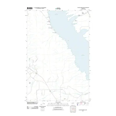
2011 Map of Canyon Ferry SW
USGS Topo · Published 2011About this map
Canyon Ferry Lake dominates the eastern half of this landscape, its western shoreline defined by a series of recreation sites and deep gulches. Recreation is a central theme of this 2011 survey, with the Lewis and Clark Picnic Area, Lorelei Picnic Area, and Orchard Picnic Area providing public access along W Shore Dr. To the south, the terrain transitions into a drainage system for several creeks, most notably Antelope Creek and Spokane Creek. Historical agricultural and water management infrastructure is evident through Potter Dam and the Potter Irrigation Dam. The presence of the Winston Cemetery near the confluence of Staubach Creek and Antelope Creek provides a focal point for genealogical interest, marking the local community's footprint near the reservoir's southern reach.
Find a feature on this map
30 named features on this map. Tap any name to fly to it.
Don’t see what you’re looking for? This feature index may not catch every label — zoom into the map to look around manually.
Map Details
Editions of this 2011 Canyon Ferry SW Map
This is the sole edition of this map. No revisions or reprints were ever made.
Other maps of this area

1886 · Fort Logan
USGS Topo · 1:250,000

1948 · White Sulphur Springs
USGS Topo · 1:250,000

1950 · Canyon Ferry
USGS Topo · 1:62,500

1950 · Townsend
USGS Topo · 1:62,500

1950 · East Helena
USGS Topo · 1:62,500

1950 · Clancy
USGS Topo · 1:62,500

1958 · White Sulphur Springs
USGS Topo · 1:250,000

1961 · White Sulphur Springs
USGS Topo · 1:250,000

1965 · White Sulphur Springs
USGS Topo · 1:250,000
1972 · Hauser Lake
USGS Topo · 1:24,000