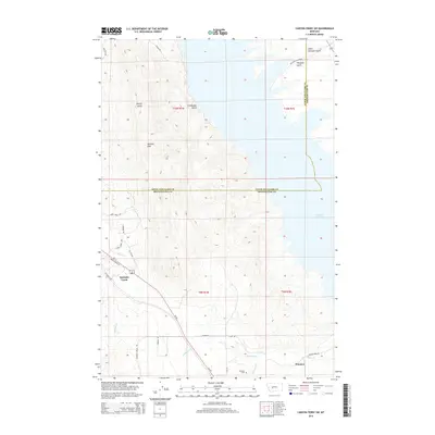
2014 Map of Canyon Ferry SW
USGS Topo · Published 2014About this map
Canyon Ferry Lake dominates the eastern boundary of this Montana landscape, where the waters meet the rugged drainages of Lewis and Clark Co and Broadwater Co. The settlement of Winston sits at the southern edge of the survey, serving as a focal point for the surrounding ranching and rural infrastructure. The terrain is defined by the Spokane Hills to the west, with several named drainages like Sheriff Gulch and Crittenden Gulch carving through the elevation toward the lake. This 2014 edition preserves the placement of the Winston Cem and various family-named roads, such as LF Baum Rd and Furman Ln, which trace the local genealogy of the area. A network of creeks, including Spokane Creek and Antelope Cr, illustrates the hydrological pattern feeding the reservoir, while Us-287 provides the primary transportation link through the valley.
Find a feature on this map
34 named features on this map. Tap any name to fly to it.
Don’t see what you’re looking for? This feature index may not catch every label — zoom into the map to look around manually.
Map Details
Editions of this 2014 Canyon Ferry SW Map
This is the sole edition of this map. No revisions or reprints were ever made.
Other maps of this area

1886 · Fort Logan
USGS Topo · 1:250,000

1948 · White Sulphur Springs
USGS Topo · 1:250,000

1950 · Canyon Ferry
USGS Topo · 1:62,500

1950 · Townsend
USGS Topo · 1:62,500

1950 · East Helena
USGS Topo · 1:62,500

1950 · Clancy
USGS Topo · 1:62,500

1958 · White Sulphur Springs
USGS Topo · 1:250,000

1961 · White Sulphur Springs
USGS Topo · 1:250,000

1965 · White Sulphur Springs
USGS Topo · 1:250,000
1972 · Hauser Lake
USGS Topo · 1:24,000