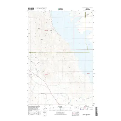
2017 Map of Canyon Ferry SW
USGS Topo · Published 2017About this map
Canyon Ferry Lake dominates the eastern landscape of this Montana quadrangle, where the waters of the Missouri River reservoir meet the rugged rising slopes of the Spokane Hills. The topography here is defined by deep drainages such as Hellgate Gulch, Sheriff Gulch, and Crittenden Gulch, which channel snowmelt toward the lake. The southern portion of the map transitions into more level terrain near the community of Winston, a settlement situated along a corridor of transport and water that includes Beaver Cr and Antelope Cr. Local history is anchored by the Winston Cem and various family-named landmarks like Furman Lr, reflecting the ranching and rural character of Broadwater Co. A network of unpaved and local roads, including Lf Baum Rd and Lazy Hm Rd, provide access to the small residential cluster at Spokane Creek.
Find a feature on this map
34 named features on this map. Tap any name to fly to it.
Don’t see what you’re looking for? This feature index may not catch every label — zoom into the map to look around manually.
Map Details
Editions of this 2017 Canyon Ferry SW Map
This is the sole edition of this map. No revisions or reprints were ever made.
Other maps of this area

1886 · Fort Logan
USGS Topo · 1:250,000

1948 · White Sulphur Springs
USGS Topo · 1:250,000

1950 · Canyon Ferry
USGS Topo · 1:62,500

1950 · Townsend
USGS Topo · 1:62,500

1950 · East Helena
USGS Topo · 1:62,500

1950 · Clancy
USGS Topo · 1:62,500

1958 · White Sulphur Springs
USGS Topo · 1:250,000

1961 · White Sulphur Springs
USGS Topo · 1:250,000

1965 · White Sulphur Springs
USGS Topo · 1:250,000
1972 · Hauser Lake
USGS Topo · 1:24,000