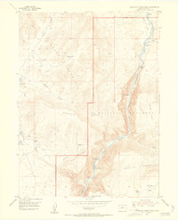
1954 Map of Canyon of Lodore North
USGS Topo · Published 1955About this map
Green River watercourses dominate this mid-century survey of the Moffat County backcountry, cutting through the dramatic geology of the Canyon of Lodore within Dinosaur National Monument. The landscape is a study in isolation and high-altitude ranching history, where family names are etched onto the terrain at Miles Place and Offield Place. Several sites are already marked as defunct by the 1950s, including Craig Place (Aband), Ecklund Cabin (Aband), and the Wade and Curtis Cabin (Aband) near the riverbank. Significant navigational hazards for early river runners are clearly identified at Upper Disaster Falls and Lower Disaster Falls. Beyond the deep canyons, the map traces livestock and travel routes like the Hoy Trail crossing Hoy Flat, providing a detailed look at the ranching infrastructure that persisted on Diamond Mountain and Offield Mountain before the area's transition to purely protected parkland.
Find a feature on this map
38 named features on this map. Tap any name to fly to it.
Don’t see what you’re looking for? This feature index may not catch every label — zoom into the map to look around manually.
Map Details
Editions of this 1954 Canyon of Lodore North Map
5 editions found
Other maps of this area

1885 · Ashley
USGS Topo · 1:250,000

1952 · Swallow Canyon
USGS Topo · 1:24,000

1954 · Lodore School
USGS Topo · 1:24,000

1954 · Canyon of Lodore South
USGS Topo · 1:24,000

1954 · Canyon of Lodore North
USGS Topo · 1:24,000

1954 · Vernal
USGS Topo · 1:250,000

1955 · Jones Hole
USGS Topo · 1:24,000

1958 · Vernal
USGS Topo · 1:250,000

1960 · Vernal
USGS Topo · 1:250,000

1966 · Big Joe Basin
USGS Topo · 1:24,000