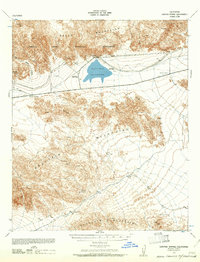
1940 Map of Canyon Spring
USGS Topo · Published 1961About this map
The Eagle Mountains and Orocopia Mountains dominate this high-desert landscape in the 1940s, providing a look at the remote terrain of eastern Riverside County before modern expansion. This survey, compiled from aerial photography, highlights the critical water infrastructure of the era, centered on the Hayfield Reservoir and its associated survey markers, Hayfield West Base and Hayfield East Base. The presence of Joshua Tree National Monument in the northwestern corner signals the early preservation of this unique environment.
Find a feature on this map
26 named features on this map. Tap any name to fly to it.
Don’t see what you’re looking for? This feature index may not catch every label — zoom into the map to look around manually.
Map Details
Editions of this 1940 Canyon Spring Map
2 editions found
Other maps of this area

1940 · Frink
USGS Topo · 1:62,500

1940 · Cottonwood Spring
USGS Topo · 1:62,500

1940 · Iris Pass
USGS Topo · 1:62,500

1940 · Canyon Spring
USGS Topo · 1:62,500

1940 · Durmid
USGS Topo · 1:62,500

1943 · Canyon Spring
USGS Topo · 1:62,500

1943 · Coxcomb Mountains
USGS Topo · 1:62,500

1943 · Pinkham Well
USGS Topo · 1:62,500

1944 · Cottonwood Spring
USGS Topo · 1:62,500

1944 · Pinkham Well
USGS Topo · 1:62,500