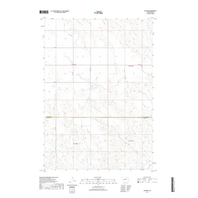
2017 Map of Capa NW
USGS Topo · Published 2017About this map
Bad River and Big Prairie Dog Creek define the drainage patterns of this Great Plains landscape, where the northern border of Jones County meets Stanley County. The terrain is a network of draws and ridges, primarily navigated by a grid of rural section-line roads such as 258th Ave and 219th St. The intersection of Stanley Co Jones Co serves as a major geographical divide in this cattle-country environment. Local infrastructure is sparse, characterized by named gravel routes including Bad River Road and Capa Road, which provide access to the remote ranchlands of Township 3 North, Range 26 East. The map reflects the enduring land use patterns of central South Dakota, where the placement of water sources and the surveyed township boundaries remain the primary markers of human organization.
Find a feature on this map
18 named features on this map. Tap any name to fly to it.
Don’t see what you’re looking for? This feature index may not catch every label — zoom into the map to look around manually.
Map Details
Editions of this 2017 Capa NW Map
This is the sole edition of this map. No revisions or reprints were ever made.
Other maps of this area

1951 · Capa
USGS Topo · 1:24,000

1951 · Van Metre
USGS Topo · 1:24,000

1951 · Capa NW
USGS Topo · 1:24,000

1951 · Capa SE
USGS Topo · 1:24,000

1954 · Midland SE
USGS Topo · 1:24,000

1954 · Pierre
USGS Topo · 1:250,000

1958 · Pierre
USGS Topo · 1:250,000
1982 · Doty Ridge
USGS Topo · 1:24,000

1982 · Hayes South
USGS Topo · 1:24,000

1982 · Hohrman Ranch
USGS Topo · 1:24,000