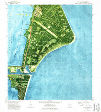
1976 Map of Cape Canaveral
USGS Topo · Published 1987About this map
Cape Canaveral Air Force Station dominates this coastal landscape, showing the density of American aerospace infrastructure during the mid-1970s. The orthophotomap detail reveals the geometric layout of numerous pads, including Launch Complex 34 and Launch Complex 39A, connected by specialized transit routes like the Skid Strip and ICBM Road. This industrial intensity is buffered by the Merritt Island National Wildlife Refuge, where the Banana River meets the shoreline at Peterson Pt and Cactus Pt. To the south, the map documents the civilian and maritime activity centered around the Canaveral Barge Canal, Trident Wharf, and the campus of Shelton College. The proximity of an ancient Indian Mound to the NASA Air Force Space Museum highlights the deep temporal layers of human occupation on the cape.
Find a feature on this map
48 named features on this map. Tap any name to fly to it.
Don’t see what you’re looking for? This feature index may not catch every label — zoom into the map to look around manually.
Map Details
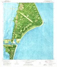
Editions of this 1976 Cape Canaveral Map
2 editions found
Other maps of this area

1949 · Orsino
USGS Topo · 1:24,000

1949 · False Cape
USGS Topo · 1:24,000

1949 · Courtenay
USGS Topo · 1:24,000

1949 · Cocoa
USGS Topo · 1:24,000

1949 · Cocoa Beach
USGS Topo · 1:24,000

1951 · False Cape
USGS Topo · 1:24,000

1951 · Cocoa
USGS Topo · 1:24,000

1951 · Courtenay
USGS Topo · 1:24,000
1951 · Cocoa Beach
USGS Topo · 1:24,000

1951 · Orsino
USGS Topo · 1:24,000