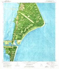
1976 Map of Cape Canaveral
USGS Topo · Published 1976About this map
Cape Canaveral Air Force Station dominates this 1976 orthophotomap, revealing the dense infrastructure of the American space program during the mid-1970s. The landscape is a network of specialized roads like ICBM Road and Skid Strip Road, connecting numerous launch facilities such as Launch Complex 34 and Launch Complex 17. The map captures a moment when the John F Kennedy Space Center (NASA) and the Merritt Island National Wildlife Refuge coexisted alongside active military and scientific operations. South of the main complex, the Canaveral Barge Canal cuts through to Port Canaveral, marking the industrial gateway to the coast. Cultural sites like the Indian Mound Cem and Shelton College near Cape View provide a deeper look at the pre-existing and emerging social layers of this specialized coastal geography.
Find a feature on this map
60 named features on this map. Tap any name to fly to it.
Don’t see what you’re looking for? This feature index may not catch every label — zoom into the map to look around manually.
Map Details
Editions of this 1976 Cape Canaveral Map
2 editions found
Other maps of this area

1949 · Orsino
USGS Topo · 1:24,000

1949 · False Cape
USGS Topo · 1:24,000

1949 · Courtenay
USGS Topo · 1:24,000

1949 · Cocoa
USGS Topo · 1:24,000

1949 · Cocoa Beach
USGS Topo · 1:24,000

1951 · False Cape
USGS Topo · 1:24,000

1951 · Cocoa
USGS Topo · 1:24,000

1951 · Courtenay
USGS Topo · 1:24,000
1951 · Cocoa Beach
USGS Topo · 1:24,000

1951 · Orsino
USGS Topo · 1:24,000