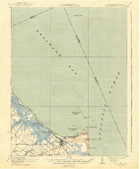
1937 Map of Cape Henlopen
USGS Topo · Published 1943About this map
Lewes serves as the focal point for this coastal survey, where the convergence of the Delaware Bay and the Atlantic Ocean creates a complex maritime landscape. The map highlights critical navigational aids such as the Cape Henlopen Light, Harbor of Refuge Light, and Brandywine Shoal Light, which guarded the entrance to the deepwater Harbor of Refuge. Inland, the landscape is defined by the marshy reaches of Broadkill Creek and the infrastructure of the Maryland and Delaware RR and Baltimore and Philadelphia RR. These rail lines, alongside the Washington Canal, illustrate the era's reliance on integrated transport for trade and travel. Local communities like Nassau and Wescoat Corners are situated near the headwaters of Red Mill Pond, reflecting a settlement pattern tied closely to both the coast and the agricultural interior of Sussex County.
Find a feature on this map
32 named features on this map. Tap any name to fly to it.
Don’t see what you’re looking for? This feature index may not catch every label — zoom into the map to look around manually.
Map Details
Editions of this 1937 Cape Henlopen Map
2 editions found

Other maps of this area

1888 · Cape May
USGS Topo · 1:62,500

1888 · Dennisville
USGS Topo · 1:62,500

1890 · Maurice Cove
USGS Topo · 1:62,500

1891 · Maurice Cove
USGS Topo · 1:62,500

1893 · Cape May
USGS Topo · 1:62,500

1894 · Dennisville
USGS Topo · 1:62,500

1898 · Cape May
USGS Topo · 1:62,500

1899 · Vineland
USGS Topo · 1:125,000

1917 · Millsboro
USGS Topo · 1:62,500

1918 · Cedar Creek
USGS Topo · 1:62,500