
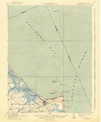
1937 Map of Cape Henlopen
USGS Topo · Published 1937About this map
Lewes serves as the focal point of this maritime landscape, where the waters of Delaware Bay and the Atlantic Ocean converge. The strategic importance of the coast is evident in the cluster of navigational aids, including Cape Henlopen Light, Harbor of Refuge Light, and the distant Brandywine Shoal Light. Inland, the map reveals a late-transitioning economy as the Maryland Delaware and Virginia RR and the Pennsylvania RR connect coastal landings with small agricultural hamlets like Nassau and Overbrook. The Lewes and Rehoboth Canal cuts through the marshy terrain near Gordon Pond, illustrating early 20th-century efforts to manage the wetlands. For genealogists, the inclusion of sites like West Hill School and family-named junctions such as Wescoat Corners and Murray Corners provides a clear record of local settlement patterns prior to mid-century development.
Find a feature on this map
27 named features on this map. Tap any name to fly to it.
Don’t see what you’re looking for? This feature index may not catch every label — zoom into the map to look around manually.
Map Details
Editions of this 1937 Cape Henlopen Map
2 editions found
Other maps of this area

1888 · Cape May
USGS Topo · 1:62,500

1888 · Dennisville
USGS Topo · 1:62,500

1890 · Maurice Cove
USGS Topo · 1:62,500

1891 · Maurice Cove
USGS Topo · 1:62,500

1893 · Cape May
USGS Topo · 1:62,500

1894 · Dennisville
USGS Topo · 1:62,500

1898 · Cape May
USGS Topo · 1:62,500

1899 · Vineland
USGS Topo · 1:125,000

1917 · Millsboro
USGS Topo · 1:62,500

1918 · Cedar Creek
USGS Topo · 1:62,500