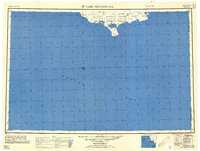
1951 Map of Cape Mendenhall
USGS Topo · Published 1958About this map
Nunivak Island dominates the northern edge of this 1951 compilation, showing the coastal fringes of the Nunivak National Wildlife Refuge. The map captures a moment in the mid-20th century before significant modern development, focusing on the remote southern coast where the Second Judicial Division meets the Fourth Judicial Division. Small settlements like Kwigamiut and Ingeramiut are noted near the shoreline, providing essential data for genealogists and researchers of Alaskan indigenous geography.
Find a feature on this map
10 named features on this map. Tap any name to fly to it.
Don’t see what you’re looking for? This feature index may not catch every label — zoom into the map to look around manually.
Map Details
Editions of this 1951 Cape Mendenhall Map
2 editions found
Other maps of this area

1951 · Kuskokwim Bay
USGS Topo · 1:250,000

1951 · Cape Mendenhall
USGS Topo · 1:250,000

1951 · Nunivak Island
USGS Topo · 1:250,000

1951 · Baird Inlet
USGS Topo · 1:250,000

1952 · Cape Mendenhall D-4
USGS Topo · 1:63,360

1952 · Cape Mendenhall D-3
USGS Topo · 1:63,360

1952 · Nunivak Island A-4
USGS Topo · 1:63,360

1952 · Nunivak Island A-7
USGS Topo · 1:63,360

1952 · Cape Mendenhall
USGS Topo · 1:250,000

1952 · Cape Mendenhall D-6
USGS Topo · 1:63,360