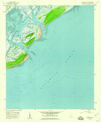
1959 Map of Capers Inlet
USGS Topo · Published 1960About this map
The tidal landscape of Charleston County's outer coast comes into sharp focus during the late 1950s, showing a network of barrier islands and protected sounds before significant modern development. Capers Island and Dewees Island remain largely untouched, separated by the deep waters of Capers Inlet and Dewees Inlet. The map documents the intricate waterways essential to coastal navigation, including the Intracoastal Waterway as it snakes through Copahee Sound and behind Isle of Palms.
Find a feature on this map
28 named features on this map. Tap any name to fly to it.
Don’t see what you’re looking for? This feature index may not catch every label — zoom into the map to look around manually.
Map Details
Editions of this 1959 Capers Inlet Map
3 editions found
Other maps of this area

1919 · The Jetties
USGS Topo · 1:21,120

1919 · Capers Island
USGS Topo · 1:21,120

1919 · Wando
USGS Topo · 1:21,120

1919 · Fort Moultrie
USGS Topo · 1:21,120

1919 · Bulls Island
USGS Topo · 1:21,120

1919 · Sewee Bay
USGS Topo · 1:21,120

1943 · Capers Island
USGS Topo · 1:24,000

1943 · Fort Moultrie
USGS Topo · 1:24,000

1943 · Wando
USGS Topo · 1:24,000

1943 · Sewee Bay
USGS Topo · 1:24,000