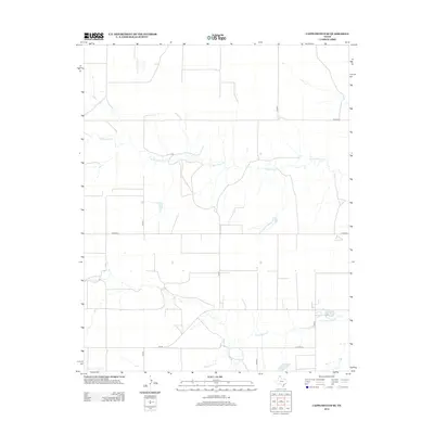
2012 Map of Capps Switch SE
USGS Topo · Published 2012About this map
The northern Panhandle landscape in Moore County is defined by the winding paths of N Palo Duro Cr and S Palo Duro Cr. This 2012 survey illustrates a sparse, agricultural region organized by a rigid grid of rural routes and farm-to-market roads. The drainage patterns of these creeks provide the only break in the geometric regularity of the land, cutting natural depressions through the high plains. Major local thoroughfares such as Fm-281, Co Road A, and Co Road D connect distant ranch sites and homesteads, reflecting the enduring rural infrastructure of the early 21st century. The map provides a clear look at the relationship between the natural watercourses and the modern surveyed property lines that dictate the region's development.
Find a feature on this map
11 named features on this map. Tap any name to fly to it.
Don’t see what you’re looking for? This feature index may not catch every label — zoom into the map to look around manually.
Map Details
Editions of this 2012 Capps Switch SE Map
This is the sole edition of this map. No revisions or reprints were ever made.
Other maps of this area

1953 · Pringle
USGS Topo · 1:24,000

1954 · Perryton
USGS Topo · 1:250,000

1954 · Amarillo
USGS Topo · 1:250,000

1958 · Perryton
USGS Topo · 1:250,000

1958 · Amarillo
USGS Topo · 1:250,000

1972 · Capps Switch
USGS Topo · 1:24,000
1972 · Pollard Creek NW
USGS Topo · 1:24,000

1974 · Morse
USGS Topo · 1:24,000
1974 · Pollard Creek NE
USGS Topo · 1:24,000

1974 · Hannas Draw East
USGS Topo · 1:24,000