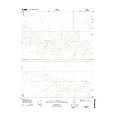
2016 Map of Capps Switch SE
USGS Topo · Published 2016About this map
Deep drainage cuts from N Palo Duro Cr and S Palo Duro Cr carve through the high plains of the Texas Panhandle on this survey. The landscape is defined by its transition between four major counties, with the intersection of Sherman, Hansford, Hutchinson, and Moore counties creating a complex jurisdictional boundary. The terrain outside the creek beds is characterized by a sparse network of section-line roads, such as Co Rd A and Co Rd 4, which support the local agricultural and ranching economy. This 2016 record shows the modern infrastructure of the region, including the arterial path of FM 281 providing essential transit across the sparsely populated plains. The contrast between the flat upland plateaus and the intricate erosion patterns of the Palo Duro creek system provides a clear picture of the area's geological and hydrological layout.
Find a feature on this map
14 named features on this map. Tap any name to fly to it.
Don’t see what you’re looking for? This feature index may not catch every label — zoom into the map to look around manually.
Map Details
Editions of this 2016 Capps Switch SE Map
This is the sole edition of this map. No revisions or reprints were ever made.
Other maps of this area

1953 · Pringle
USGS Topo · 1:24,000

1954 · Perryton
USGS Topo · 1:250,000

1954 · Amarillo
USGS Topo · 1:250,000

1958 · Perryton
USGS Topo · 1:250,000

1958 · Amarillo
USGS Topo · 1:250,000

1972 · Capps Switch
USGS Topo · 1:24,000
1972 · Pollard Creek NW
USGS Topo · 1:24,000

1974 · Morse
USGS Topo · 1:24,000
1974 · Pollard Creek NE
USGS Topo · 1:24,000

1974 · Hannas Draw East
USGS Topo · 1:24,000