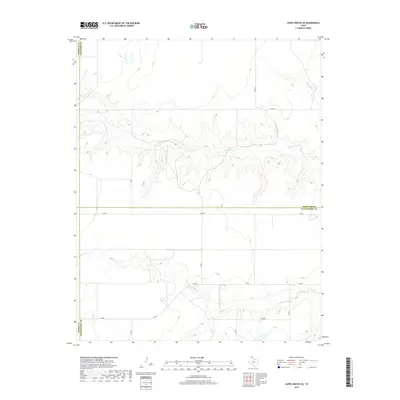
2019 Map of Capps Switch SE
USGS Topo · Published 2019About this map
Deep drainage cuts from N Palo Duro Cr and S Palo Duro Cr define this High Plains landscape where the boundaries of Moore, Hutchinson, Hansford, and Sherman counties meet. This survey provides a clear view of the regional rural infrastructure, including FM 281 and a grid of maintained routes like Co RD A and Co RD 4. The map illustrates how these waterways have carved significant relief into the otherwise flat agricultural tableland, creating a complex network of draws and breaks. For those studying the Texas Panhandle, it documents the modern distribution of property access and water resources in a region where geography is shaped by the relentless action of intermittent prairie creeks.
Find a feature on this map
14 named features on this map. Tap any name to fly to it.
Don’t see what you’re looking for? This feature index may not catch every label — zoom into the map to look around manually.
Map Details
Editions of this 2019 Capps Switch SE Map
This is the sole edition of this map. No revisions or reprints were ever made.
Other maps of this area

1953 · Pringle
USGS Topo · 1:24,000

1954 · Perryton
USGS Topo · 1:250,000

1954 · Amarillo
USGS Topo · 1:250,000

1958 · Perryton
USGS Topo · 1:250,000

1958 · Amarillo
USGS Topo · 1:250,000

1972 · Capps Switch
USGS Topo · 1:24,000
1972 · Pollard Creek NW
USGS Topo · 1:24,000

1974 · Morse
USGS Topo · 1:24,000
1974 · Pollard Creek NE
USGS Topo · 1:24,000

1974 · Hannas Draw East
USGS Topo · 1:24,000