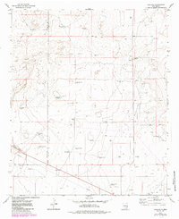
1973 Map of Caprock
USGS Topo · Published 1985About this map
Caprock and the nearby Caprock Ranch anchor this landscape along the border of Chaves and Lea counties during the early 1970s. The region is defined by a heavy reliance on groundwater, illustrated by a dense network of specialized watering points including Church Pasture Windmill, Bull Pasture Well, and Heifer Well. These names reflect the specific livestock management practices of the High Plains ranching economy of the era.
Find a feature on this map
27 named features on this map. Tap any name to fly to it.
Don’t see what you’re looking for? This feature index may not catch every label — zoom into the map to look around manually.
Map Details
Editions of this 1973 Caprock Map
2 editions found
Other maps of this area

1954 · Brownfield
USGS Topo · 1:250,000

1958 · Brownfield
USGS Topo · 1:250,000

1962 · Brownfield
USGS Topo · 1:250,000

1973 · Mescalero Point
USGS Topo · 1:24,000

1973 · Soldier Hill
USGS Topo · 1:24,000

1973 · Caprock
USGS Topo · 1:24,000

1973 · Mescalero Point NE
USGS Topo · 1:24,000
1973 · Lane Salt Lake
USGS Topo · 1:24,000
1973 · Dallas Store
USGS Topo · 1:24,000

1978 · Flying M Ranch
USGS Topo · 1:24,000