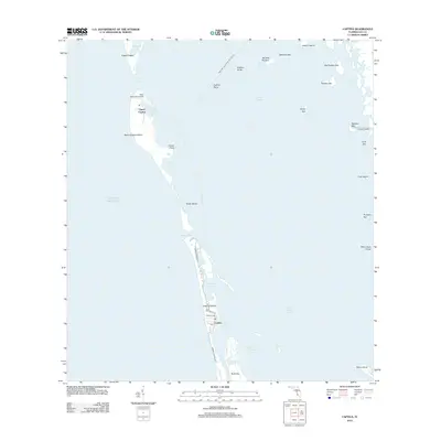
2012 Map of Captiva
USGS Topo · Published 2012About this map
North Captiva Island and Captiva Island form the primary landmasses in this coastal survey, separated by the inlet of Redfish Pass. The map details a shifting shoreline between the Gulf of Mexico and the interior waters of Pine Island Sound. Development is concentrated on the southern island near the settlement of Captiva, where S Seas Plantation Rd and Sanibel Captiva Rd provide access to homes and resorts near Chadwick Bayou. To the north, Upper Captiva remains more isolated, anchored by the Salty Approach Airport and Safety Harbor. The eastern edge of the sound is dotted with numerous small keys, including Big Bird Rookery, Hemp Key, and Josslyn Island, while the southern portion of the quadrangle is defined by the sheltered waters of Roosevelt Channel and Braynerd Bayou behind Buck Key.
Find a feature on this map
40 named features on this map. Tap any name to fly to it.
Don’t see what you’re looking for? This feature index may not catch every label — zoom into the map to look around manually.
Map Details
Editions of this 2012 Captiva Map
This is the sole edition of this map. No revisions or reprints were ever made.
Other maps of this area

1956 · Tampa
USGS Topo · 1:250,000

1956 · Charlotte Harbor
USGS Topo · 1:250,000

1958 · Matlacha
USGS Topo · 1:24,000

1958 · Captiva
USGS Topo · 1:24,000

1958 · Port Boca Grande
USGS Topo · 1:24,000

1958 · Sanibel
USGS Topo · 1:24,000

1958 · Pine Island Center
USGS Topo · 1:24,000

1958 · Bokeelia
USGS Topo · 1:24,000
1958 · Wulfert
USGS Topo · 1:24,000

1959 · Tampa
USGS Topo · 1:250,000