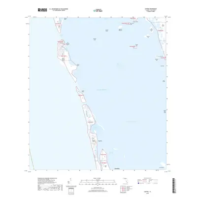
2018 Map of Captiva
USGS Topo · Published 2018About this map
Captiva Island and its northern neighbor North Captiva Island dominate this coastal survey of the Lee County barrier islands. The landscape is defined by the narrow ribbon of land separating the Gulf of Mexico from the shallow waters of Pine Island Sound. This geography reveals a distinct maritime and residential character, with Salty Approach Airport and Safety Harbor serving the isolated northern island, while the main settlement of Captiva is connected via Captiva Drive. The intricate network of tidal channels, including Redfish Pass, Roosevelt Channel, and Buck Key Channel, highlights the dynamic nature of these islands. Further inland, the map documents numerous small keys such as Josslyn Island and Demere Key, which have served as significant landmarks and ecological points within the Intracostal Waterway system.
Find a feature on this map
48 named features on this map. Tap any name to fly to it.
Don’t see what you’re looking for? This feature index may not catch every label — zoom into the map to look around manually.
Map Details
Editions of this 2018 Captiva Map
This is the sole edition of this map. No revisions or reprints were ever made.
Other maps of this area

1956 · Tampa
USGS Topo · 1:250,000

1956 · Charlotte Harbor
USGS Topo · 1:250,000

1958 · Matlacha
USGS Topo · 1:24,000

1958 · Captiva
USGS Topo · 1:24,000

1958 · Port Boca Grande
USGS Topo · 1:24,000

1958 · Sanibel
USGS Topo · 1:24,000

1958 · Pine Island Center
USGS Topo · 1:24,000

1958 · Bokeelia
USGS Topo · 1:24,000
1958 · Wulfert
USGS Topo · 1:24,000

1959 · Tampa
USGS Topo · 1:250,000